< Back to Calendar
February 10, 2023 -
Begins at 6:00 PM
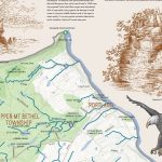 Landmarks and Waterways: Illustrated Maps of the Lehigh and Delaware River Watershed
An exhibit of eleven large scale maps that highlight the history, geology, and ecology of the Lehigh Valley region. This exhibit is a culmination of a four-year collaboration with Pocono Mountain, Bucks County, and Lehigh Valley watershed associations, water resource scientist Rebecca Hayden, designer Keri Maxfield, and illustrator Tom Maxfield. These maps were created to bring each watershed to life for residents and visitors, presenting the landscape, historical and natural features, and the narrative story of what makes each watershed unique.
The process of each map’s creation involved the assembly of various layers of information using ArcGIS – roads, elevation contours, parks, rivers and streams, lakes, and historical features. Elements of each map were then hand drawn onto these layers. Each watershed group worked collaboratively on writing the particular story of their own area. Drawings of natural and historical features highlighting each map, along with beautiful color illustrations of the watershed’s wildlife were added to tell these stories. The finished pieces of art hang in public areas around the region, offering visitors a fresh perspective on the land, historical, and water resources that surround them.
This exhibit is sponsored by Lehigh County Authority.